Southbound, this “first stop” at Milepost 5.8 offers a perfect blend of the natural and cultural history of the region. The early European settlers of the Appalachian Mountains forged a living from the native materials so abundant around them. Hickory, chestnut, and oak trees provided nuts for food, logs for building, and tannin for curing hides, while the rocks were put to use as foundations and chimneys and stone fences. Visitors can tour a collection of 19th century farm buildings via the Mountain Farm Trail. The area also houses a Visitor Center with exhibits and other information.
Humpback Rocks Hiking Trails
 The Humpback Rocks area at the northern end of the Blue Ridge Parkway offers a wonderful variety for the serious and casual hiker. Visitors will find both the natural and cultural world of the southern Appalachian mountains opening up before them.
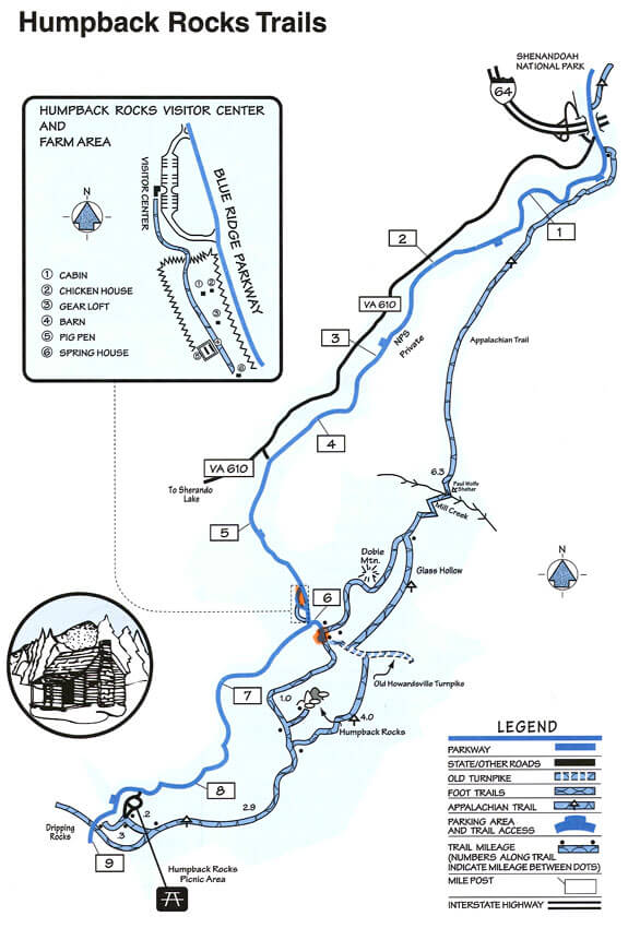
Download the Humpback Rocks trails map.
Mountain Farm Trail
The Mountain Farm Trail begins at the Humpback Rocks Visitor Center (MP 5.9). This is an easy .25 mile hike through an outdoor museum that is reminiscent of an 1890s mountain farm. During the summer months, costumed interpreters demonstrate southern Appalachian mountain life at the turn of the century. The gravel path leads past the cabin to other outbuildings associated with many mountain farms. The slightly inclined gravel path can accommodate wheelchairs.
Humpback Rocks Trail
The Humpback Rocks Trail, which begins at the south end of the Humpback Gap parking area, provides access to Humpback Rocks (1 mile), Humpback Mountain (2 miles), and the Humpback Rocks picnic area (3.9 miles). About a half-mile up the blue-blazed trail, hikers can reach Humpback Rocks from a spur trail on the left. The strenuous 700-foot climb rewards hikers with spectacular views of the Rockfish and Shenandoah Valleys. Hikers continuing straight at the fork for one mile can reach the summit of Humpback Mountain to view ridges to the north. Beyond the summit, the trail winds a half-mile along the top of a cliff to a trail leading to the Humpback Rocks picnic area. Generally, the Humpback Rocks trail is marked with blue blazes on trees, rocks, and other natural features. At times, however, the trail is also part of the Appalachian Trail and may be marked in white. A single blaze indicates the trail continues straight while a double blaze indicates an upcoming turn. Wear appropriate hiking shoes and carry drinking water. Allow one hour to Humpback Rocks, two hours to Humpback Mountain, and four hours to hike to the picnic area.
Old Howardsville Turnpike Trail
Old Howardsville Turnpike begins at Humpback Gap parking area (MP 6.0) and descends 3.5 miles into Rockfish Valley. The Turnpike was built between 1846 and 1851. It connected the trade markets of the Shenandoah Valley with the James River canal system. Original rock walls are still along this historic trace, but hiking this route is not recommended as the roadbed is not maintained.
Catoctin Trail
Catoctin Trail begins at the Humpback Rocks Picnic Area (MP 8.5). This .3 miles leg stretcher leads to an overlook of the Shenandoah Valley and the western horizon.
Appalachian Trail
The Appalachian Trail can also be accessed from the Humpback Gap parking area. Southbound hikers can reach it by continuing south on the Humpback Rocks trail. Northbound hikers can reach it taking the one mile blue blazed path at the northern end of the parking lot, or the one mile white blazed path just off of the Howardsville Turnpike. The Appalachian Trail is the nation’s premier hiking path, stretching 2,000 miles from Maine to Georgia. Throughout much of Virginia, it parallels the Blue Ridge Parkway. The trail is marked with white blazes.