Exit the Blue Ridge Parkway at milepost 86 to spend some time at the Peaks of Otter. For more than 8,000 years, people have traveled through this area. Native Americans passed through the area while hunting, and the earliest European settlers began arriving in the mid-1700’s. By 1834 the first inn had opened, and by the turn of the century the Peaks of Otter had become a popular tourist destination.
Today the Peaks of Otter is still a major developed area on the Blue Ridge Parkway. In the valley formed by Sharp Top, Flat Top, and Harkening Hill is a lodge and restaurant, visitor center, campground, picnic area and historic farm. In addition, the area is almost totally surrounded by the Jefferson National Forest, which only adds to its appeal as a destination for Parkway visitors.
The Johnson Farm and Polly Wood’s Ordinary represent two historic periods at the Peaks. Polly Wood’s cabin served as the first lodging for travelers through the area starting in the early 1830’s. The Johnson Farm sheltered three generations of the Johnson family, and today it is a living history farm during the summer where you can play games, help work the garden, or just sit on the porch and relax in a rocking chair.
Peaks of Otter Hiking Trails
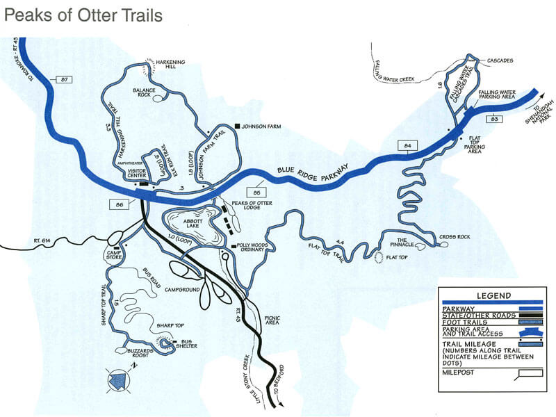 The mountains of Peaks of Otter all have trails ranging from less than a mile to more than four miles, and there is nearby access to the Appalachian Trail.
Download the Peaks of Otter trails map.
Sharp Top Trail (1.5 miles)
Sharp Top Trail is the most popular trail and originates at the campstore across the Parkway from the Visitor Center. This is a steep and strenuous route and should be attempted only by those in good health. Drinking water should be carried as none is available at the top. The summit offers an impressive 360-degree view of the Peaks of Otter area, the Piedmont to the east, the Blue Ridge Mountains, and the Shenandoah Valley with the Alleghany Mountains to the west. Allow two hours for hiking up and one hour for hiking down. Add an extra half-hour for the spur trail to Buzzard’s Roost, a series of large rock formations offering different views of the area. Concession-operated bus service (one-way or round trip) to within one quarter mile of the top is available seasonally. Hiking along the bus road is prohibited.
Elk Run Loop Trail (0.8 miles)
Elk Run Loop Trail begins behind the Visitor Center. It is a moderately strenuous trail and is self-guiding with written displays describing the forest community. For a leisurely walk, allow one hour.
Harkening Hill Loop Trail (3.3 miles)
Harkening Hill Loop Trail begins behind the Visitor Center and across from the amphitheater. This woodland trail climbs to a ridge where distant views are possible. A spur path near the summit leads to Balance Rock, an immense boulder balanced on a small rock.
Johnson Farm Trail (2.0 miles)
Johnson Farm Trail is a loop trail which follows a section of the Harkening Hill Loop Trail. Beginning at the north end of the Visitor Center parking area, the trail takes you 1.1 miles to the Johnson Farm, which was started in 1852. Living history demonstrations are presented on a seasonal basis. Allow two to three hours for a leisurely visit.
Flat Top Trail
Flat Top Trail was designated with Fallingwater Cascades Trail as a continuous National Recreation Trail in April 1982. Flat Top rises to an elevation of 4,004 feet with many scattered rock outcrops. The Pinnacle and Cross Rock are names given to such formations. On this trail, hikers can experience the changing forest ecology as they climb or descend 1,600 feet from the Parkway trail heads.
Fallingwater Cascades Trail
Fallingwater Cascades Trail, the other segment of the National Recreation Trail (see Flat Top Trail), is a loop trail which takes hikers along cascades on Fallingwater Creek with its huge rock outcrops clothed in rhododendron and large hemlocks. This trail drops 260 feet below the Fallingwater Parking Area; hikers should be prepared to climb that elevation on their return. Experiencing this mountain cascade is well worth the effort.
Abbott Lake Trail (1.0 miles)
Abbott Lake Trail, the least difficult of these trails, is a loop around Abbott Lake. The trail takes hikers through a woodland forest and open field, offering a close-up view of this picturesque lake.
Peaks of Otter Campground & Lodge Information
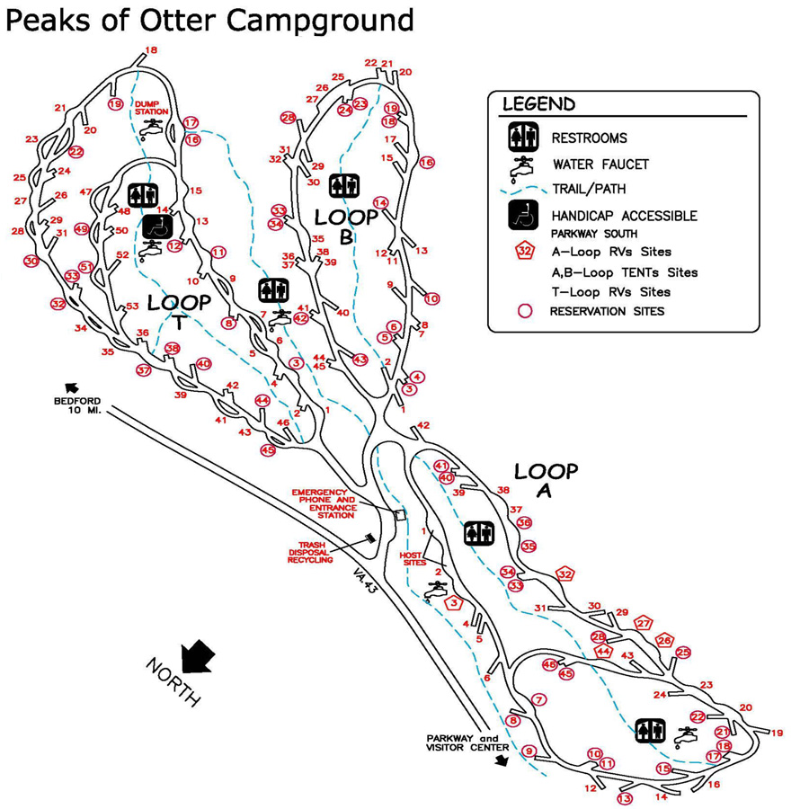 82 Tent Sites | 59 RV sites | 62 Picnic Sites
Other: Camping Supplies; Telephone; Self-guiding trails; Fishing; Visitor Center
Download the Peaks of Otter Campground Map.
The Peaks of Otter Lodge sits beneath the peaks beside the Peaks of Otter Lake. The Lodge, located at milepost 86, features comfortable rooms, fine dining, meeting facilities, a lounge, and a gift shop.