Rocky Knob is an accurate description of the shape of the mountain that bears its name. Today the Rocky Knob area offers many diversions for the visitor, including a visitor center and campground. Located near the intersection of the Parkway with Virginia Route 8, the Rocky Knob recreation area covers more than 4000 acres. Interpretive talks and demonstrations are given in the summer months and four trails offer a variety of scenic and historical wonders. Three large picnic areas, hikes into Rock Castle Gorge (known for its beautiful rock crystalline quartz formations), and the wonderful agricultural scenes along the roadway make this a truly unique portion of the Blue Ridge Parkway. The Rocky Knob Cabins, built by the Civilian Conservation Corps in the 1930s, offer the only cabins for rent on the length of the Parkway.
The lush and forested slopes of Rock Castle Gorge suggest that man has been an infrequent visitor here, but that is not the case. A century ago this gorge supported a substantial community of 30 families. Most residents were farmers who raised hogs and grew corn, and who hunted and harvested wild plants. The community’s traditional life was altered dramatically in the late 1800’s when industry entered the area. Independent mountaineers quickly became dependent on the cash income that nearby cotton mills and timber companies provided. Over the years, people moved elsewhere to work. By the 1920’s, fewer and fewer families called these rugged “hollers” home.
In the decades that followed, nature reclaimed the gorge. Today, more than 60 species of native trees, 25 species of delicate ferns and over 200 species of wildflowers shade and color the gorge and its remnants of old home sites and gristmills. Wild turkey, fox, deer, bobcat and other animals roam the forest, plying their ancient patterns and rhythms of life.
Rocky Knob Hiking Trails
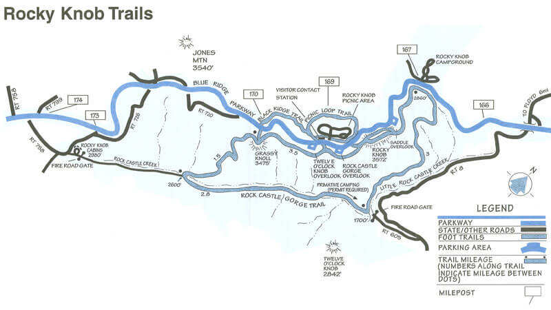 To avoid confusion, the major trails in the Rocky Knob area have blaze markings in different colors. All connecting trails are blazed in red.
Download the Rocky Knob hiking trails map.
Rock Castle Gorge Trail (10.8 miles)
The Rock Castle Gorge Trail, blazed with green, is a moderate to strenuous loop with elevations ranging from 3,572 feet at Rocky Knob to 1,700 feet at the confluence of Rock Castle and Little Rock Castle Creeks. Parts of the trail are rocky and several sections are quite steep. To avoid the most strenuous uphill sections, hikers can begin at the Rocky Knob Campground and head downhill toward Rock Castle Creek.In 1984, the Rock Castle Gorge Loop Trail was designated a National Scenic Trail in recognition of its outstanding features.
From the campground, the trail descends over 1,000 feet in 3 miles, passing through a cove hardwood forest of oaks, hickories, tulip trees, basswoods, maples, magnolias and a stand of bigtooth aspens. Along the ridge, there is a beautiful display of mountain laurel. This is a good place to look for evidence of homesites.
The 2.8-mile section of trail along Rock Castle Creek follows the gated fire road. Within .5, it passes a back-country campground on the site of a former Civilian Conservation Corps complex. A permit is required and may be obtained free from the Rocky Knob Campground, Ranger Station or Visitor Center. Camping in Rock Castle Gorge is permitted only at this designated back-country site. The large white house on the left is privately owned and is not open to the public. After steadily climbing beyond the house, there are excellent views of the creek, 100 feet below. This area has a fabulous display of wildflowers in April and early May. Rock Castle Cascades on the left is a prominent landmark.
Turn right at the trail junction where the trail passes through a mesic-hardwood forest. This forest type occurs in ravines and along bases of slopes in the gorge. Here soil is moist, deep and rich. It supports a highly diverse herbaceous layer, as well as unusual cove tree species like black maple. The Rock Castle Gorge Trail gains 875 feet in the next 1.5 miles. After .5 mile, the trail goes through an extensive boulder field known as the Bare Rocks, and a ridge near the rim of the gorge has an impressive stand of Catawba rhododendron and mountain laurel.
From Grassy Knoll back to the campground the trail parallels the Parkway and presents views of Rock Castle Gorge, the Piedmont, and the countryside north of Floyd, Virginia. The trail to Rocky Knob is narrow and steep, and affords outstanding views. Just downhill from Rocky Knob, an Appalachian Trail shelter serves as a reminder that the famous “AT” used to wend its way along this part of the Blue Ridge Parkway before its relocation to the west in the 1950s.
Black Ridge Trail (3.0 miles)
The Black Ridge Trail, blazed with blue, is a moderate loop that is most conveniently started and finished at the Rocky Knob Visitor Center. Passing through second growth forest to a seldom-used gravel road, it includes good views to the north from atop Black Ridge, then crosses the Parkway to join the Rock Castle Gorge Trail for its return to the Visitor Center. There are excellent views from this section of trail into Rock Castle Gorge and the Piedmont.
Rocky Knob Picnic Area Trail (1.0 miles)
The Rocky Knob Picnic Area Trail (yellow blaze) is an easy loop and offers a pleasant walk through a mature forest of large oaks, ashes, hickories, Fraser magnolias, hemlocks, and other native trees and shrubs. The area is excellent for bird watching, particularly in the nesting season.
Smart View Trail (2.6 miles)
Several miles north of Rocky Knob (milepost 154.5), the Smart View Trail, an easy to moderate loop around the Smart View Picnic Area, offers good views into Piedmont Virginia. The trail is level for the most part and is generally dry and smooth underfoot. Most of the trail passes through mature woods and has a good display of wildflowers in April and May. Several signs mark access points from the Picnic Area to the trail. Two hours should be allowed for its completion.
Rocky Knob Campground Information
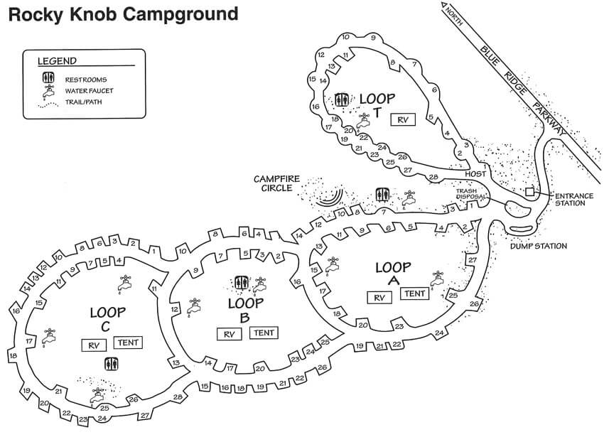 81 Tent Sites | 28 RV sites | 72 Picnic Sites
Other: Telephone; Self-guiding trails; Fishing; Visitor Center, Campfire circle
Rocky Knob Campground has easy access to Rockcastle Gorge and is just nine miles from Mabry Mill. Reservations can be made for portions of this campground. This campground has a campfire circle that accommodates up to 150 campers.
For the more adventurous, backcountry camping is permitted at the designated site in Rock Castle Gorge. A permit is required and can be obtained for any time of the year. For those in primitive camping areas, keep in mind the following: camping and campfires are only allowed in designated areas, only dead firewood may be gathered for fuel, pack out all trash, do not use soap or shampoo in any streams, and toilet facilities must be at least 200 feet from water supplies.
Rocky Knob’s campground usually opens in May.
Download the Rocky Knob Campground map.