Doughton Park is an area of open meadows, ideal for viewing wildlife and visiting numerous historic locations. It is one of the best places along the Blue Ridge Parkway to view white-tailed deer, raccoons, red and grey foxes, and bobcats, as well as spectacular shows of flame azalea and rhododendron in the late spring. There are craft demonstrations and ranger talks throughout the summer and a campground open seasonally. Hiking opportunities range from a short hike at Fodder Stack Trail to the strenuous 7.5-mile Bluff Mountain Trail. Visit the Brinegar Cabin or hike into Basin Cove to view the Caudill Family Homestead.
Originally known as the Bluffs, this area came by its present name in honor of Congressman Robert L. Doughton, a long-time advocate and supporter of the Blue Ridge Parkway.
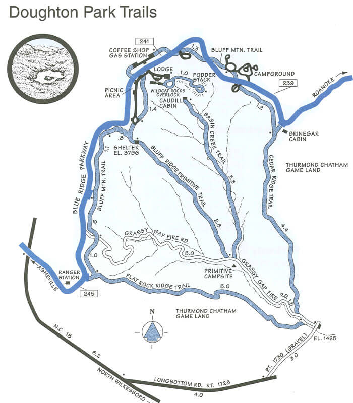
Doughton Park Hiking Trails
 More than 30 miles of hiking trails meander through Doughton Park’s pastures and along its streams. Visitors can stretch their legs on modest strolls or embark on more ambitious, day-long outings.
Download the Doughton Park trails map.
Bluff Mountain Trail (7.5 miles)
Bluff Mountain Trail, popular with “flatlanders,” offers many scenic vistas and traverses relatively level terrain. The trail runs near the Parkway and is accessible from many locations along its 7.5 mile route from Brinegar Cabin to Basin Cove Overlook.
Cedar Ridge Trail (4.4 miles)
Cedar Ridge Trail skirts the northern side of Doughton Park’s “V-shaped” boundary. Beginning near Brinegar Cabin, the trail descends a forested ridgeline 4.4 miles to the Grassy Gap Fire Road. The elevation change is more than 2,000 feet, making this a beautiful but strenuous trip.
Grassy Gap Fire Road (6.5 miles)
Grassy Gap Fire Road is a 6.5 mile leaf-covered lane, wide enough for hikers or horseback riders to travel side by side. The trail starts at Milepost 243.9 and ambles down the mountainside past the primitive campground to State Route 1730 (Longbottom Road). Horseback riders must enter and exit from Longbottom Road. Bicycles and motorized vehicles are prohibited.
Basin Creek Trail (3.3 miles)
Basin Creek Trail, accessible only from the Grassy Gap Fire Road, winds past cascading waterfalls for 3.3 miles to the century-old Caudill Cabin, former home of the Martin Caudill family. Part of the once-thriving Basin Cove community, this cabin was one of the few structures that withstood the devastating 1916 flood. Allow plenty of time for the 3.3 mile return trip and for the additional hike along Grassy Gap Fire Road.
Bluff Ridge Primitive Trail (2.8 miles)
Bluff Ridge Primitive Trail is the shortest but steepest route into Basin Cove. The strenuous climb up the trail makes the hike seem much longer than 2.8 miles.
Flat Rock Ridge Trail (5.0 miles)
Flat Rock Ridge Trail begins on the mountain-top meadow at Basin Cove Overlook and ends on the damp, cool banks of Basin Cove Creek alongside the Grassy Gap Fire Road. The trial offers glimpses of rugged mountain slopes that attracted and challenged early settlers.
Fodder Stack Trail (2.0 miles)
Fodder Stack Trail, 2 miles round trip, shows off its delicate display of wildflowers in spring and rewards hikers year-round with the varied hues and fragrances of mixed pine and hardwood forest. Most of the trail is easy to moderate, with a short steep section at the start. Recommended for families, the trail represents a cross-section of Parkway environments.
Doughton Park Campground Information
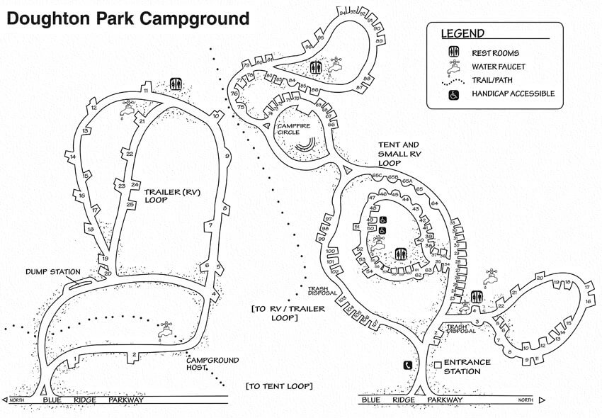 110 Tent Sites | 25 RV sites | 56 Picnic Sites
Other: Camping Supplies; Telephone; Fishing; Campfire Circle
Doughton Park is located at Milepost 241.1 near Basin Cove, Bluffs Lodge, and an extensive trail system including the Bluff Mountain and Fodder Stack trails. Doughton Park is one of the largest developed areas on the Parkway and usually opens in May.
Download the Doughton Park Campground map.