The James River/Otter Creek Recreation Area (MP 60.9) features a campground, gift shop, visitor information, picnic area, hiking trails, and fishing in Otter Lake.
The James River has been a major transportation artery through Virginia for centuries. Although originally planned to provide a navigable waterway from Great Falls at Richmond to the Ohio River, the James River and Kanawha Canal was destined to extend no further west than Buchanan. When completed in 1851, it was the primary commercial route in the state. But civil war, floods, and railroads spelled disaster for the canal, causing it to fail within the next thirty years. Near the James River Visitor Center, visitors can see one of the restored canal locks.
Otter Creek and James River Trails
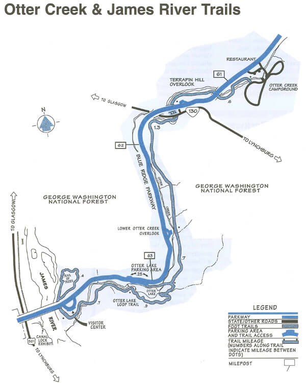 As Otter Creek descends to the James River, the Blue Ridge Parkway dips to its lowest elevation, roughly 650 feet above sea level. This area’s abundant water and warmer temperatures support plant and animal communities that are unlike those found at other areas on the Parkway. A short walk along the Trail of Trees or a hike along the clear, cool waters of Otter Creek will give ample proof that there is more to the Blue Ridge Parkway than mountain-top vistas.
Download the Otter Creek and James River trails map.
Otter Creek Trail (3.5 miles)
Otter Creek Trail parallels the Parkway road as it stretches from Otter Campground to the James River Visitor Center. Most sections of this trail are easy to hike and can be reached from many points along the motor road.
Otter Lake Loop Trail (0.9 miles)
Otter Lake Loop Trail provides scenic views of Otter Lake. This is also a good trail for watching wildlife. Look for beaver lodges and dams along tributary streams. Early morning and late evening are prime times for wildlife observation.
Trail of Trees (0.4 miles)
Trail of Trees begins near the James River Visitor Center and wanders through a shaded stream drainage. Trail signs identify many of the trees and shrubs of the river valley. This trail also affords a handsome view of the James River water gap, a rare geological feature.
Canal Lock Trail (0.4 miles)
Canal Lock Trail begins at the Visitor Center and crosses the James River on a walkway built beneath the bridge. The restored Battery Creek Lock, located a short distant from the bridge, is typical of those constructed in the 1800s as part of the James River and Kanawha Canal. This canal, with nearly 100 locks, helped make the river a major transportation corridor before the Civil War. Exhibits at the Battery Creek site explain how locks were used to raise and lower boats to adjust for the changing elevation of the river.
Otter Creek Campground
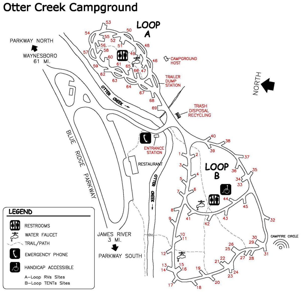
45 Tent Sites | 24 RV sites | 0 Picnic Sites
Telephone; Self-guiding trails; Fishing; Visitor Center
The Otter Creek Campground is located at milepost 60.9 near the Parkway’s lowest elevation near Virginia’s James River. This campground has sites for 45 tents and 24 RV trailers. Facilities currently include water, comfort stations with flush toilets and sinks, a telephone, and a visitor center. Area hikes include the Trail of Trees, Otter Creek, Otter Lake Loop and James River Canal Trails.
Contact telephone: 434-299-5941.
Download the Otter Creek Campground Map.