Linville Falls is a beautiful series of dramatic falls that drop to a deep gorge, accessed by a trail lined with rare virgin stands of white pine and hemlock. The area around the Falls is one of the few places in these mountains where the Rosebay, Catawba, and Carolina Rhododendron grow side by side. A campground and picnic area along the Linville River is among the most popular on the Parkway. The various trails here include the short walk up Duggers Creek and more strenuous walks along the Linville Gorge. There is a visitor center here as well as a number of off-the-Parkway motels, bed-and-breakfast inns, and campgrounds.
The visitor’s center is reached via an access road found off milepost 316.4. It offers a quaint Blue Ridge Parkway store with gifts, accessories, and information about both the Falls and the Parkway. The Visitor’s Center also has restrooms, water fountains, and a detailed map of the trails in the area. Outside of the visitor center are picnic grounds, self guided trails, campgrounds, campfire talks, nature walks, and trout fishing. The self guided trail here follows the Linville River through the Upper and Lower Falls, and then takes you to Linville Gorge. There are numerous overlooks on the trail from which to experience the Falls and surrounding forests.
Linville Falls Hiking Trails
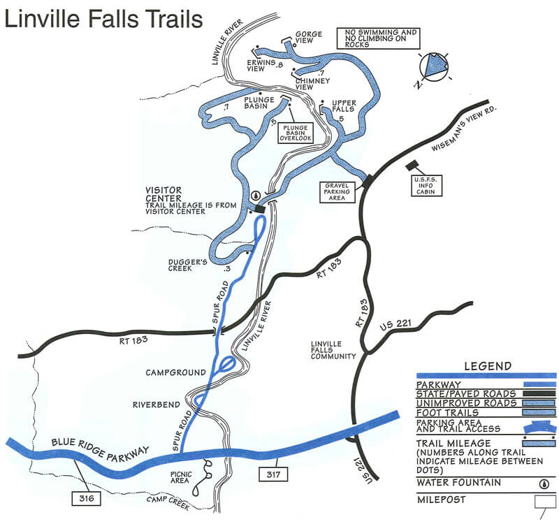 Two main hiking trails lead to beautiful views of the Linville Falls. Both begin at the Linville Falls Visitor Center and pass through remnants of a virgin hemlock forest mixed with other familiar trees such as white pine, oaks, hickory, and birch. A colorful and varied display of wildflowers decorates the trails in spring. Red and golden leaves in fall beautifully contrast with the soothing green of hemlocks. The Linville Falls trails range in difficulty from moderate to strenuous.
Download the Linville Falls trails map.
Erwins View Trail
Erwins View Trail, a moderate walk of 1.6 miles round- trip, offers hikers four overlooks, each revealing a different aspect of the Linville Falls area. The first overlook is 0.5 miles from the visitor center, and is a moderate walk with a slight loss of elevation. Here, the Linville River spills gently over the upper falls where it widens and pauses. Drifting into a narrow canyon, the water suddenly spirals out of sight and plunges 45 feet over the lower falls.
The next overlook, Chimney View, 0.7 miles from the visitor center, is the first point on the trail where the lower falls can be seen. It offers an excellent chance to photograph both the upper and lower falls. The overlook is named for the chimney-like rock outcroppings located to the right of the waterfall. The trail is strenuous in this area with considerable elevation gain. At Gorge View Overlook, hikers can see the Linville River cutting its way through the Linville Gorge Wilderness Area.
The Erwins View Trail ends at Erwins View Overlook, 0.8 mile from the visitor center. From this vantage point hikers can enjoy a panoramic view of the Linville Gorge and a distant view of the upper and lower falls.
Linville Gorge & Plunge Basin Trail
The trails to Linville Gorge (1.4 miles round trip) and to Plunge Basin (1 mile round trip) also start at the visitor center. The trail to Linville Gorge forks 0.2 mile from the visitor center. The right fork takes hikers to Plunge Basin Overlook where they can view the lower falls and the Chimneys. The left fork winds down through rock cliffs to the bottom of the falls where the force of the water cascading over the falls creates a large pool. Both of these trails are strenuous. SWIMMING AND CLIMBING ON THE ROCKS ARE PROHIBITED.
Linville Falls Campground Information
50 Tent Sites | 20 RV sites | 100 Picnic Sites
Other: Self-guiding trails; Fishing; Visitor Center; Group Camping
Linville Falls is located at Milepost 316 on the Linville River and has access to the trail system into the Linville Gorge Wilderness Area and usually opens in April. It is the Parkway’s smallest, most popular campground and the only developed site on the Parkway that allows group camping. Reservations can be made for portions of this campgound on-line.